Version 2, updated on 01/04/2021.
 |
 |
 |
 |
 |
| Terra | Aqua | Suomi-NPP | NOAA-20 | FY |
|---|
Satellites Directly Received by the AIRCentre's DRS in Terceira, Azores
| Satellite | Description | Orbit Characteristics |
|---|---|---|
| Terra (EOS/AM-1) | Earth observing mission within NASA’s ESE program between the United States, Japan and Canada with the objective of observing Earth’s atmosphere, ocean, land, snow and ice, and energy budget [1]. Its launch date was on 18/12/1999 and it has already exceeded its design life, however it is still operating until the present date [2]. |
Type: Sun-synchronous Altitude: 705km Inclination: near-polar Eccentricity: near-circular Period: 99min LTDN: 10:30hr Cycle: 16days |
| Aqua (EOS/PM-1) | Earth observing mission within NASA’s ESE program with the objective of studying the water cycle, including the interrelated processes (atmosphere, oceans and land surface) and their relationship to Earth system changes [3]. Its launch date was on 04/05/2002 and it has already exceeded its design life, however it is still operating until the present date without the HSB instrument and with AMSR-E in a reduced mode [3], [4]. |
Type: Sun-synchronous Altitude: 705km Inclination: near-polar Eccentricity: near-circular Period: 98.8min LTAN: 13:30hr Cycle: 16days |
| Suomi-NPP (NPP) | NPP (NPOESS Preparatory Project) is a joint NASA and NOAA mission. SNPP is the predecessor to the JPSS series spacecraft, and its main objectives and capabilities include climate change, health of the ozone layer, natural disasters, weather predictions, vegetation, global ice cover, air pollution, temperatures and Earth’s energy budget [5]. Its launch date was on 28/10/2011 and it has already exceeded its design life, however it is still operating until the present date [6]. |
Type: Sun-synchronous Altitude: 824km Inclination: near-polar Eccentricity: near-circular Period: 101min LTDN: 10:30hr Cycle: 16days |
| NOAA-20 (JPSS-1) | This satellite is a clone of the Suomi-NPP with similar instruments that was launched into space on 18/11/2017 as the first spacecraft of NOAA’s next generation of polar-orbiting satellites. NOAA-20 is still operating to the present day and is located in the same orbit as SNPP, although the two satellites are separated in time and space by 50 minutes [7], [8]. | Type: Sun-synchronous Altitude: 824km Inclination: near-polar Eccentricity: near-circular Period: 101min LTAN: 13:30hr Cycle: 20days |
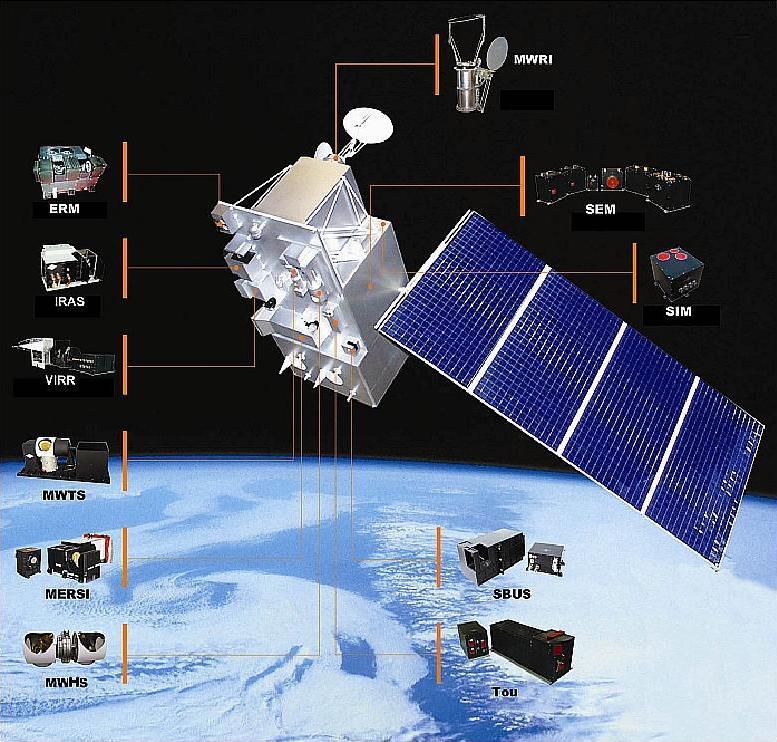
| FengYun-3 | FY-3 satellites are China’s 2nd generation polar-orbiting meteorological satellites with four main objectives: provide global meteorological parameters to numerical weather prediction, monitor natural disasters and surface ecological environment, provide weather information on any part of the world for specialized activities, and provide geophysical parameters to global change studies [9].
FY-3A: Launched on 27/05/2008, its end of service was on 01/03/2018. It had a substantial contribution to ocean and ice monitoring, climate monitoring, atmospheric chemistry and space weather. It was the first unit of the FY-3 series [10]. FY-3B: Launched on 04/11/2010, it is still operating until the present day without ERM-1 [10]. FY-3C: Launched on 23/09/2013, it is still operating until the present day, but only with 6 instruments switched on [10]. FY-3D: Launched on 15/11/2017, it is still operating until the present day [10]. |
FY-3A Type: Sun-synchronous Altitude: 836km Inclination: near-polar Eccentricity: near-circular Period: 101.5min LTDN: 10:15hr Cycle: 6days FY-3B Type: Sun-synchronous Altitude: 836km Inclination: near-polar Eccentricity: near-circular Period: 101.5min LTAN: 13:40hr Cycle: 6days FY-3C Type: Sun-synchronous Altitude: 836km Inclination: near-polar Eccentricity: near-circular Period: 101.5min LTDN: 10:00hr Cycle: 6days FY-3D Type: Sun-synchronous Altitude: 836km Inclination: near-polar Eccentricity: near-circular Period: 101.5min LTAN: 14:00hr Cycle: 6days |
Figures
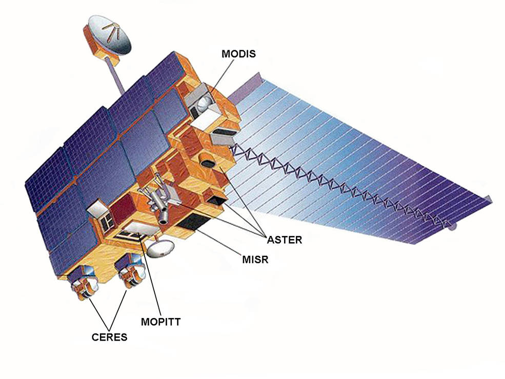
Figure 1 - Terra Spacecraft (Credits: NASA).
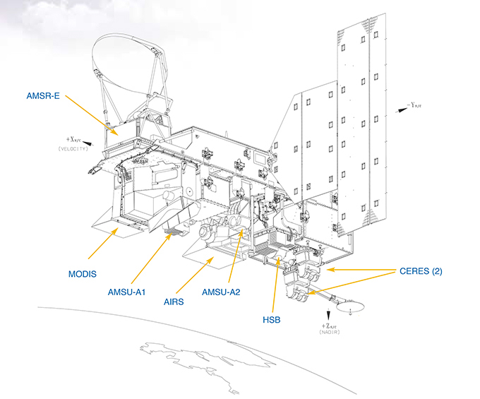
Figure 2 - Aqua Spacecraft (Credits: NASA).
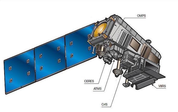
Figure 3 - Suomi-NPP Spacecraft (Credits: NASA).
Figure 4 - NOAA-20 Spacecraft (Credits: NASA, NOAA).
Figure 5 - FY-3A/B Spacecraft (Credits: CMA, NSMC).
Version 2, updated on 01/04/2021.
Satellite Instrumentation on board of each spacecraft
| Satellite | Instrumentation | |
|---|---|---|
| Terra | ASTER, CERES, MISR, MODIS and MOPITT. | |
| Aqua | AIRS, AMSR-E, AMSU-A, CERES, HSB and MODIS. | |
| Suomi-NPP | ATMS, CERES, CrIS, OMPS and VIIRS. | |
| NOAA-20 | ATMS, CERES, CrIS, OMPS and VIIRS. | |
| FengYun-3 | A/B | ERM-1, IRAS, MERSI-1, MWHS-1, MWRI, MWTS-1, SBUS, SEM, SIM-1, TOU, VIRR. |
| C | ERM-1, GNOS, IRAS, MERSI-2, MWHS-2, MWRI, MWTS-2, SBUS, SEM, SIM-1, TOU, VIRR. | |
| D | GAS, GNOS, HIRAS, IPM, MERSI-2, MWHS-2, MWRI, MWTS-2, SEM, WAI. | |
Instrument Descriptions
| Instrument | Description | Spatial Resolution [km] | Swath [km] |
|---|---|---|---|
| AIRS | Atmospheric InfraRed Sounder – High spectral resolution instrument that aims to obtain highly accurate temperature profiles. It is the AIRS/AMSU-A/HSB triplet instrument centered on measuring accurate temperature and humidity profiles throughout the atmosphere [4]. | 1 - 13.5 | 1650 |
| AMSR-E | Advanced Microwave Scanning Radiometer for Eos – It measures precipitation rate, cloud water, water vapor, sea surface winds, sea surface temperature, ice, snow and soil moisture [4]. | 4 - 43 | 1445 - 1450 |
| AMSU-A | Advanced Microwave Sounding Unit-A – Designed to obtain temperature profiles in the upper atmosphere (especially the stratosphere) and to provide a cloud-filtering capability for tropospheric temperature observations. It is part of the AIRS/AMSU-A/HSB triplet of instruments [4]. | 40 - 48 | 1650 - 2250 |
| ASTER | Advanced Spaceborne Thermal Emission and Reflection Radiometer – Provides data to create detailed maps of land surface temperature, emissivity, reflectance and elevation. It produces high-resolution (15 to 90 square meters per pixel) images of the Earth in 14 different bands. Wavelength region includes VNIR, SWIR and TIR, however current SWIR data is unavailable [2]. | 0.015 - 0.090 | 60 |
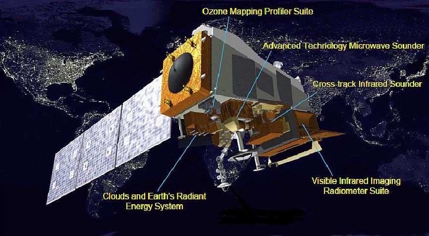
| ATMS | Advanced Technology Microwave Sounder – Provides atmospheric temperature and moisture for operational weather and climate applications. It also collects microwave radiation from the Earth’s atmosphere and surface all day and night, even through clouds. ATMS is currently aboard of the SNPP and NOAA-20. Together, ATMS and CrIS provide data on the hydrological cycle [7]. | 16 - 75 | 2200 - 2600 |
| CERES | Clouds and Earth’s Radiant Energy System – It measures the Earth’s total radiation budget and provides cloud property estimates that enable to assess clouds’ roles in radiative fluxes from the surface to the top of the atmosphere [2]. There are two CERES sensors aboard Terra (FM1 and FM2), two aboard Aqua (FM3 and FM4), one on Suomi-NPP (FM5) and another on NOAA-20 (FM6) [11]. | 20 - 30 | 3000 |
| CrIS | Cross-track Infrared Sounder – Provides more accurate, detailed atmospheric temperature and moisture observations for weather and climate applications. It also presents information on greenhouse gases, primarily in the middle and upper atmosphere. CrIS is currently aboard of the SNPP and NOAA-20. Together, CrIS and ATMS provide data on the hydrological cycle [7]. | 14 - 16 | 2200 |
| ERM | Earth Radiation Measurement – ERM-1 is designed with two wide spectral band channels for Earth radiation budget measurement. The solar constant and the earth reflected shortwave and emitted long-wave radiative flux at the top of the atmosphere are the two products generated by this measurement [12]. | 28 | 2200 - 2300 |
| GAS | Greenhouse gases Absorption Spectrometer – Operating in four NIR/SWIR bands, the main objective of GAS is atmospheric chemistry, mainly the measurement of CO2, CH4, CO and N2O [13]. Replacement of TOU/SBUS [14]. | 10 | 100 |
| GNOS | GNSS Occultation Sounder – Receives the GNSS signal occulted by the Earth atmosphere and ionosphere. Measuring the phase delay, GNOS can retrieve atmospheric refractivity, temperature, pressure, water vapor profiles and electron density profiles [12]. | 0.5 - 300 | 710 - 1100 |
| HIRAS | Hyperspectral Infra-Red Atmospheric Sounder – Provides high-precision atmospheric temperature and humidity profiles. It also measures ozone, methane and carbon dioxide. Replacement of IRAS [14]. | 16 | 2250 |
| HSB | Humidity Sounder for Brazil – Aimed at obtaining humidity profiles throughout the atmosphere even under conditions of heavy cloudiness and haze. It is part of the AIRS/AMSU-A/HSB triplet of instruments [4]. | 13.5 | 1650 |
| IPM | Ionospheric Photo-Meter – X-ray spectrometry of the ionosphere [13]. Measures the total electrons and oxygen-nitrogen ratio at the ionospheric altitude [12]. | 30 - 80 | — |
| IRAS | Infra-Red Atmospheric Sounder – Has a total of 26 spectral channels providing initial field information about temperature and humidity for numerical weather prediction models [12]. | 17 | 2250 |
| MERSI | Medium Resolution Spectral Imager – MERSI-1 has 20 channels mainly located in the VIS and NIR spectral regions. MERSI and VIRR can be used together with the radiance measurements of the sounding instruments to handle clouds. This instrument can be used to measure chlorophyll, suspended sediments, aerosols and water vapor, and to monitor natural disasters and environmental impact [12]. MERSI-2 is an integration of VIRR and MERSI-1’s channels [14]. | 0.25 - 1 | 2900 |
| MISR | Multi-angle Imaging SpectroRadiometer – Views the Earth with cameras pointed at nine different angles. Provides maps of planetary and surface albedo; amount and type of atmospheric aerosol particles; amount, types, and heights of clouds; and vegetation properties [1] [2]. | 0.25 - 0.275 | 380 |
| MODIS | MODerate resolution Imaging Spectrometer – Views every point on the world every 1-2 days in 36 discrete spectral bands. It measures cloud cover and properties, aerosols, distribution of temperature and water vapor and photosynthetic activity of land and marine plants. It also helps in tracking the sources and sinks of carbon dioxide, fires and changes on the land surface. There is another MODIS instrument aboard Aqua [2]. | 0.25 - 1 | 2230 - 2300 |
| MOPITT | Measurements Of Pollution In The Troposphere – It measures emitted and reflected radiance from the Earth in three spectral bands. It is designed to focus on the distribution, transport, sources and sinks of carbon monoxide. It has spatial resolution of 22km [2]. | 22 | 640 |
| MWHS | Micro-Wave Humidity Sounder – Primary purpose is moisture sounding in cloudy regions. This instrument is similar to the AMSU-B. MWHS-2 is an improved version of MWHS-1 designed for observing the distribution of global atmospheric thermodynamics and monitoring the severe convective systems in all-weather conditions [12]. | 16 - 32 | 2700 |
| MWRI | Micro-Wave Radiation Imager – Its main objective is multi-purpose imagery with emphasis on precipitation [13]. This is also an all-weather instrument that measures thermal microwave emission of land and ocean surfaces, and measures various forms of water in the atmosphere, clouds and surfaces [12]. | 12 - 80 | 1400 |
| MWTS | Micro-Wave Temperature Sounder – Its main purpose is nearly-all-weather temperature sounding, which is very important for numerical weather forecast, disaster monitoring and climate changes [12]. MWTS-2 is a replacement of MWTS-1 with a performance close to AMSU-A [14]. | 32 - 70 | 2200 - 2250 |
| OMPS | Ozone Mapping and Profiler Suite – Tracks the health of the ozone layer and measures the concentration of ozone in the Earth’s atmosphere with high fidelity and large swaths, it is also able to measure other atmospheric particles. OMPS-N and OMPS-L currently fly aboard SNPP, NOAA-20 only has OMPS-N on board [7]. | 2.2 - 300 | 500 - 2800 |
| SBUS | Solar Backscatter Ultraviolet Sounder – UV ozone sounding instrument capable of generating products with ozone vertical profile [12]. | 50 - 200 | — |
| SEM | Space Environment Monitoring – Its main objective is space weather (charged particles) [13]. | — | — |
| SIM-1 | Solar Irradiance Monitor – Solar radiation monitoring instrument for monitoring solar irradiance variation [12]. | — | — |
| TOU | Total Ozone Unit – TOU and SBUS are sensors that measure the atmospheric ozone distribution [12]. | 50 | 3000 |
| VIIRS | Visible Infrared Imaging Radiometer Suite – Collects visible and infrared imagery of land, atmosphere, cryosphere and oceans using 16 spectral channels with moderate spatial resolution. It provides daytime and nighttime imaging of any point on the Earth every day, generating many critical environmental products about snow and ice cover, clouds, fog, aerosols, fire, smoke plumes, dust, vegetation health, phytoplankton abundance and chlorophyll. VIIRS is currently aboard of the SNPP and NOAA-20 [6], [7]. | 0.375 - 0.75 | 3000 |
| VIRR | Visible and Infra-Red Radiometer – It has 10 channels including the high sensitivity visible channel. The primary purpose is to monitor global cloud cover, identification of cloud height, type and phase. VIRR also aims at detecting sea surface temperature, monitoring vegetation growth conditions, detecting ocean color, and more [12]. | 1.1 | 2800 |
| WAI | Wide-field Auroral Imager – Its main objective is observation of Aurora [13]. | 10 | — |
For more information on satellite instruments visit: https://www.wmo-sat.info/oscar/instruments.
Version 2, updated on 01/04/2021.
DRS Products Generated at the AIR Centre
Available Soon!
Other Existing Online Data Sources
Note: In order to download the products presented in the following table, you will need to create a NASA EARTHDATA login, click here to create a new account.
| Main Instrument | How to access the products? |
|---|---|
| AIRS | GES DISC (Goddard Earth Sciences Data and Information Services Center):
|
| AMSR-E | NSIDC (National Snow & Ice Data Center):
|
| AMSU-A | GES DISC (Goddard Earth Sciences Data and Information Services Center):
You can also use the links indicated on the AIRS instrument to access AMSU-A data, as they work together to obtain some products. |
| ASTER | EARTHDATA LP DAAC (Land Processes Distributed Active Archive Center):
|
| ATMS | Use the following links to access the data:
|
| CERES | EARTHDATA ASDC (Atmospheric Science Data Center):
|
| CrIS | Use the following links to access the data:
|
| ERM | Access the products related to this instrument on the NSMC main page by clicking here. You can also use the FENGYUN Satellite Data Center by clicking here. |
| GAS | Access the products related to this instrument on the NSMC main page by clicking here. You can also use the FENGYUN Satellite Data Center by clicking here. |
| GNOS | Access the products related to this instrument on the NSMC main page by clicking here. You can also use the FENGYUN Satellite Data Center by clicking here. |
| HIRAS | Access the products related to this instrument on the NSMC main page by clicking here. You can also use the FENGYUN Satellite Data Center by clicking here. |
| HSB | GES DISC (Goddard Earth Sciences Data and Information Services Center):
You can also use the links indicated on the AIRS instrument to access HSB data, as they work together to obtain some products. |
| IPM | Access the products related to this instrument on the NSMC main page by clicking here. You can also use the FENGYUN Satellite Data Center by clicking here. |
| IRAS | Access the products related to this instrument on the NSMC main page by clicking here. You can also use the FENGYUN Satellite Data Center by clicking here. |
| MERSI | Access the products related to MERSI-1 on the NSMC main page by clicking here, or here for MERSI-2. You can also use the FENGYUN Satellite Data Center by clicking here. |
| MISR | EARTHDATA ASDC (Atmospheric Science Data Center):
|
| MODIS | EARTHDATA LP DAAC (Land Processes Distributed Active Archive Center):
|
| MOPITT | EARTHDATA ASDC (Atmospheric Science Data Center):
|
| MWHS | Access the products related to MWHS-1 on the NSMC main page by clicking here, or here for MWHS-2. You can also use the FENGYUN Satellite Data Center by clicking here. |
| MWRI | Access the products related to this instrument on the NSMC main page by clicking here. You can also use the FENGYUN Satellite Data Center by clicking here. |
| MWTS | Access the products related to MWTS-1 on the NSMC main page by clicking here, or here for MWTS-2. You can also use the FENGYUN Satellite Data Center by clicking here. |
| OMPS | Use the following links to access the data:
|
| SBUS | Access the products related to this instrument on the NSMC main page by clicking here. You can also use the FENGYUN Satellite Data Center by clicking here. |
| SEM | Access the products related to this instrument on the NSMC main page by clicking here. You can also use the FENGYUN Satellite Data Center by clicking here. |
| SIM-1 | Access the products related to this instrument on the NSMC main page by clicking here. You can also use the FENGYUN Satellite Data Center by clicking here. |
| TOU | Access the products related to this instrument on the NSMC main page by clicking here. You can also use the FENGYUN Satellite Data Center by clicking here. |
| VIIRS | LAADS DAAC (Level-1 and Atmosphere Archive & Distribution System Distributed Active Archive Center):
|
| VIRR | Access the products related to this instrument on the NSMC main page by clicking here. You can also use the FENGYUN Satellite Data Center by clicking here. |
| WAI | Access the products related to this instrument on the NSMC main page by clicking here. You can also use the FENGYUN Satellite Data Center by clicking here. |
Version 2, updated on 01/04/2021.
Glossary
CMA – China Meteorological Administration
DRS – Direct Receiving Station
EOS – Earth Observing Satellite
ESA – European Space Agency
ESE – Earth Science Enterprise
FM – Flight Module
FTP – File Transfer Protocol
GNSS – Global Navigation Satellite System
JPSS – Joint Polar Satellite System
LTAN – Local Time on Ascending Node
LTDN – Local Time on Descending Node
NASA – National Aeronautics and Space Administration
NIR – Near Infrared
NOAA – National Oceanic and Atmospheric Administration
NPOESS – National Polar-orbiting Operational Environmental Satellite System
NPP – National Polar-Orbiting Partnership
NSMC – National Satellite Meteorological Center
SWIR – Short Wave Infrared
TIR – Thermal Infrared Radiometer
VIS – Visible
VNIR – Visible Near Infrared
Version 2, updated on 01/04/2021.
References
[1] H. J. Kramer, "Terra," ESA, 2002. [Online]. Available: https://earth.esa.int/web/eoportal/satellite-missions/t/terra. [Accessed March 2021].
[2] K. Thome, T. Owen and 610 WebDev, "About Terra," NASA, 23 March 2021. [Online]. Available: https://terra.nasa.gov/about. [Accessed March 2021].
[3] H. J. Kramer, "Aqua," ESA, 2002. [Online]. Available: https://earth.esa.int/web/eoportal/satellite-missions/a/aqua. [Accessed March 2021].
[4] C. Parkinson, S. Graham and P. Przyborski, "About Aqua," NASA, 22 March 2021. [Online]. Available: https://aqua.nasa.gov/content/about-aqua. [Accessed March 2021].
[5] B. Dunbar and K. Hille, "NPP Mission Overview," NASA, 4 March 2020. [Online]. Available: https://www.nasa.gov/missionpages/NPP/missionoverview/index.html. [Accessed March 2021].
[6] H. J. Kramer, "Suomi NPP," ESA, 2002. [Online]. Available: https://earth.esa.int/web/eoportal/satellite-missions/s/suomi-npp. [Accessed March 2021].
[7] NASA and NOAA, "Mission and Instruments," NASA/NOAA, [Online]. Available: https://www.jpss.noaa.gov/missionandinstruments.html. [Accessed March 2021].
[8] ESA, "JPSS-1/NOAA-20," ESA, [Online]. Available: https://directory.eoportal.org/web/eoportal/satellite-missions/content/-/article/noaa-20. [Accessed March 2021].
[9] NSMC and CMA, "FY-3 Series Satellites," NSMC, 2010. [Online]. Available: https://www.nsmc.org.cn/en/NSMC/Channels/FY-3SeriesSatellites.html. [Accessed March 2021].
[10] NSMC and CMA, "Satellite Program," NSMC, 2010. [Online]. Available: http://www.nsmc.org.cn/en/NSMC/Channels/FY_3A.html. [Accessed March 2021].
[11] N. Loeb and E. Kizer, "General Product Info," NASA, 15 March 2021. [Online]. Available: https://ceres.larc.nasa.gov/data/general-product-info/. [Accessed March 2021].
[12] NSMC and CMA, "FengYun Satellite Instrument," NSMC, 2018. [Online]. Available: https://fy4.nsmc.org.cn/nsmc/en/instrument/index.html. [Accessed March 2021].
[13] ESA, "FY-3 (FengYun-3)," ESA, [Online]. Available: https://directory.eoportal.org/web/eoportal/satellite-missions/content/-/article/fy-3. [Accessed March 2021].
[14] NSMC and CMA, "FY-3 Series," NSMC, [Online]. Available: https://fy4.nsmc.org.cn/nsmc/en/satellite/FY3.html. [Accessed March 2021].